Overview
The article underscores the paramount significance of mastering the Puget Sound water depth map, asserting its vital role in navigation safety, ecological research, resource management, and climate change monitoring. For anyone working on the water, a precise Puget Sound water depth map combined with a reliable marine area reference is the foundation of safe and informed decision-making.
Accurate depth mapping is not merely a technical necessity; it is instrumental in avoiding hazards, informing scientific studies on marine ecosystems, guiding sustainable fisheries practices, and tracking environmental changes in coastal areas. Modern hydrographic surveys often feed into a high-resolution Puget Sound nautical chart used by mariners, researchers, and coastal planners alike.
This comprehensive understanding of depth mapping is indispensable for anyone involved in these critical fields. Before major field campaigns or voyages, experts routinely review a specialized Puget Sound depth chart that highlights key contours, gradients, and critical depth zones across the region.
Introduction
Navigating the intricate waterways of Puget Sound demands a keen understanding of its underwater landscape, where water depth mapping is not just important but pivotal. This essential practice enhances navigation safety while simultaneously supporting ecological research and effective resource management in the region. To prepare for complex crossings, many operators study a detailed map of Puget Sound showing channels, shoals, islands, and submerged structures alongside real-time marine data.
However, the complexities of creating an accurate water depth map raise critical questions:
- How can one effectively master the methodologies behind these maps?
- What real-world applications can be derived from them?
This tutorial will guide readers through the necessary steps to harness the power of water depth mapping, revealing its significance for both marine ecosystems and human activities. By the end, you will be more confident reading a clear marine map that Puget Sound users rely on to understand depth, hazards, and bottom features.
Explore the Importance of Water Depth Mapping in Puget Sound
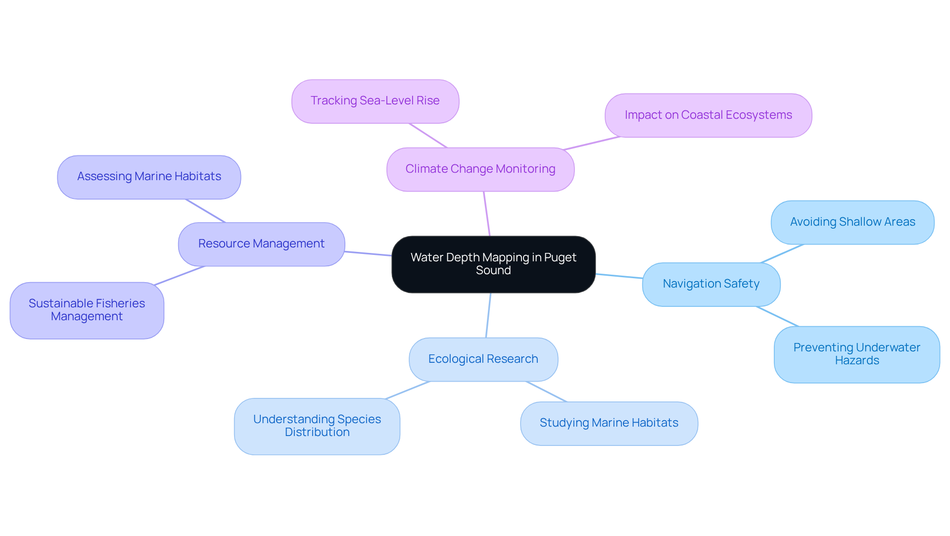
Water depth mapping in Puget Sound is essential for several compelling reasons:
- Navigation Safety: Accurate depth maps empower mariners to avoid shallow areas and underwater hazards, ensuring safe passage through the intricate waterways of Puget Sound.
- Ecological Research: The Puget Sound water depth map provides crucial data for studying marine habitats, enabling scientists to understand the distribution of species and the health of ecosystems.
- Resource Management: Effective management of fisheries and other marine resources hinges on precise measurement information, including the Puget Sound water depth map, to assess habitats and plan sustainable practices.
- Climate Change Monitoring: Understanding variations in levels is vital for tracking the effects of climate change, including sea-level rise and its impact on coastal ecosystems, as shown in the Puget Sound water depth map.
Taken together, these applications rely heavily on a well-maintained set of Puget Sound marine charts that integrate depth, shoreline, and bottom-structure information for multiple user groups. In summary, water level mapping transcends mere technical necessity; it serves as an indispensable tool for preserving the ecological integrity of the region and ensuring safe navigation for all users of its waters.

Analyze the Geological and Hydrological Features of Puget Sound
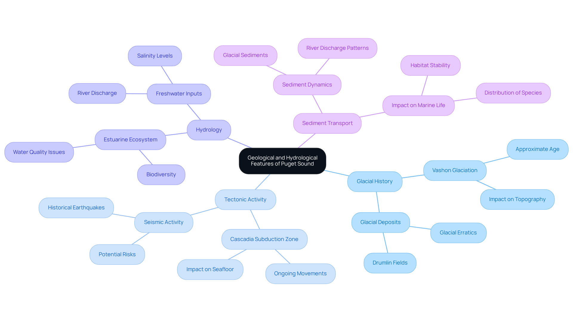
The geological and hydrological features of Puget Sound are intricately shaped by a combination of natural processes.
Glacial History: The region's topography stands as a testament to its glacial past, significantly influenced by the Vashon Glaciation approximately 15,000 years ago. This glacial activity resulted in a complex terrain characterized by deep basins, such as the Main Basin, which averages 323 feet in depth, alongside shallower regions that critically affect marine habitats, as shown in the Puget Sound water depth map. Overall, according to the Puget Sound water depth map, the body of water has an average depth of around 70 meters (approximately 230 feet). These glacially carved basins are clearly visible on a modern Puget Sound topographic map that highlights steep fjord-like walls and broad shallow shelves.
Tectonic Activity: Situated within the Cascadia subduction zone, the region undergoes ongoing tectonic movements that contribute to the dynamic nature of its seafloor. These movements not only influence the Puget Sound water depth map but also play a crucial role in shaping habitat distribution, with the deepest point on the map reaching 286 meters offshore of Point Jefferson, part of the Main Basin. For geologists, comparing seismic data with a high-detail depth chart of Puget Sound that marks basins, sills, and fault-controlled structures reveals how active the system remains.
Hydrology: The distinctive estuarine ecosystem of the region arises from the interaction between freshwater inputs from rivers and saltwater from the Pacific Ocean. This interaction generates varying salinity levels, essential for supporting diverse marine biodiversity. The average salinity of the body of water is approximately 28.5 parts per thousand, reflecting its brackish nature. The total volume of water in the region is around 168 km³, underscoring its significance as a large estuary.
Sediment Transport: Understanding sediment transport patterns is vital for effective mapping, as they significantly impact habitat stability and the distribution of marine life. The region's sediment dynamics are shaped by glacial deposits and ongoing river discharge, with an average monthly river discharge of about 41,000 cubic feet per second. These pathways are easier to interpret when viewed on a nautical map of Puget Sound showing channels, deltas, and depositional fans.
By examining these characteristics, we gain a deeper understanding of the complex interactions among geology, hydrology, and marine ecosystems in the region, emphasizing its importance as a crucial ecological area.

Understand the Methodologies for Creating a Water Depth Map
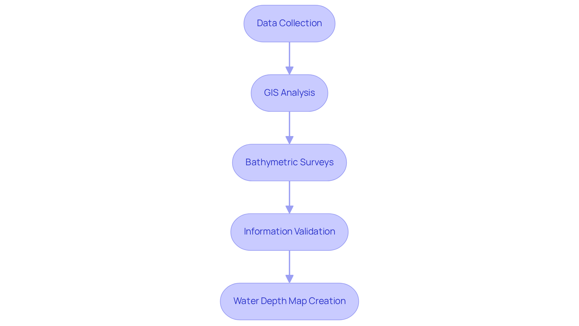
Creating a water depth map requires a mastery of several key methodologies that ensure precision and reliability. To support accurate modeling, analysts often compare data against a trusted Puget Sound marine map that outlines depth changes across key estuarine basins.
-
Data Collection: Employ sonar technology, including single-beam and multi-beam sonar systems, to gather precise depth data for the Puget Sound water depth map across various locations. These systems are essential for capturing detailed underwater topography, revealing features such as underwater mountains and valleys. Multibeam sonar, specifically, offers high-resolution information that enhances our understanding of the seafloor's intricacy.
-
Geographic Information Systems (GIS): Utilize GIS software to process and analyze the gathered information. This technology enables the visualization of depth variations and underwater features, facilitating a comprehensive understanding of the seafloor's characteristics. Distinct visualization techniques provided by GIS can layer intricate information, such as streams and political boundaries, thereby enriching the overall comprehension of the data. Marine GIS specialists frequently import layers from a digital nautical map of Puget Sound to validate depth intervals and seabed contours before final rendering.
-
Bathymetric Surveys: Conduct thorough bathymetric surveys to obtain detailed information about the seafloor's topography. These surveys are essential for precise mapping and are frequently backed by advanced sonar systems that enhance resolution. Furthermore, bathymetric surveys play a vital role in environmental impact assessments and conservation efforts, helping to identify vulnerable marine ecosystems. Survey teams often cross-reference findings with an updated Puget Sound depth chart to confirm basin structure consistency across multiple zones.
-
Information Validation: Ensure the precision of the measurement information by cross-referencing it with existing nautical charts and conducting field verifications. This step is crucial for confirming the reliability of the mapping results, as field verifications validate the sonar data against real-world conditions.
Validation steps commonly include alignment with a standardized Puget Sound water depth chart to ensure depth accuracy across tidal variations. By adhering to these methodologies, one can create dependable and informative water level maps, such as the Puget Sound water depth map, that serve various purposes, from navigation safety to ecological research, ultimately aiding in improved marine resource management.

Apply Insights from the Water Depth Map to Real-World Scenarios
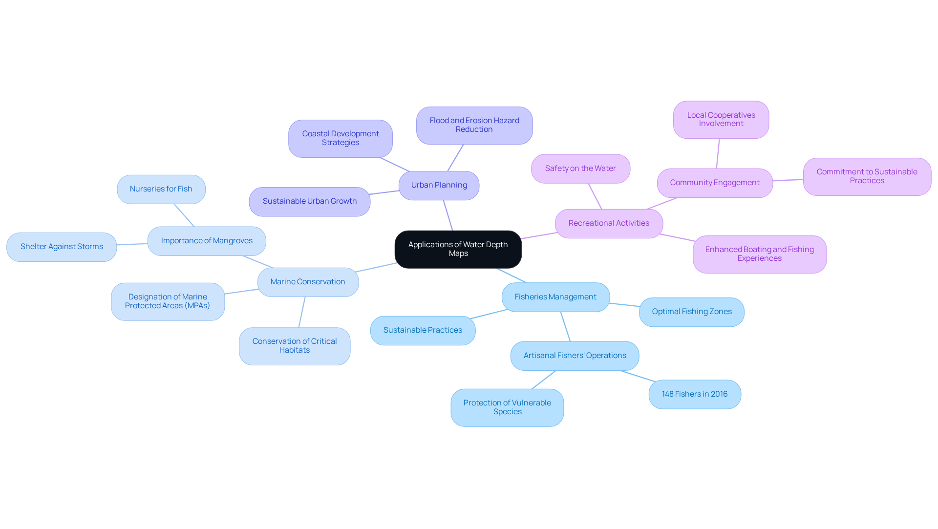
Insights gained from water depth maps can be effectively applied across various real-world scenarios:
-
Fisheries Management: Depth maps are instrumental in identifying optimal fishing zones, crucial for sustainable practices. In 2016, 148 skilled artisanal fishers operated from the Mahebourg landing station, relying on such information to safeguard vulnerable species and ensure that fishing activities do not exhaust resources.
-
Marine Conservation: Mapping data plays a vital role in the designation of marine protected areas (MPAs). These areas are essential for conserving critical habitats and maintaining biodiversity, providing safe havens for marine life to thrive without the pressures of fishing and development. The significance of mangroves, which serve as nurseries for fish and are crucial for local fisheries, underscores the necessity for effective conservation strategies. Environmental teams often note that conservation boundaries correlate strongly with patterns shown on the Puget Sound nautical charts, which highlight ecologically sensitive depth zones.
-
Urban Planning: Incorporating elevation maps into coastal development strategies is crucial for reducing hazards linked to flooding and erosion. This proactive approach ensures that urban growth is safe and sustainable, protecting both infrastructure and natural ecosystems. Understanding the multiple values associated with coastal ecosystems can guide effective planning.
-
Recreational Activities: Supplying detailed information to recreational boaters and fishermen enriches their experiences while encouraging safety on the water. Knowledge of the Puget Sound water depth map can prevent accidents and improve fishing success, thereby making recreational activities more enjoyable and responsible. Engaging local cooperatives in these efforts fosters a sense of ownership and commitment to sustainable practices. For recreational mariners, a simplified map of Puget Sound is often used to ensure safer route choices and hazard avoidance.
By leveraging these insights, stakeholders can make informed decisions that benefit both the environment and the community, ensuring the sustainable use of Puget Sound's resources.

Conclusion
Mastering water depth mapping in Puget Sound transcends mere technicality; it is an essential step toward ensuring safe navigation, ecological preservation, and sustainable resource management. The intricate interplay of geological and hydrological features shapes the region's underwater landscape, making accurate mapping indispensable for a multitude of applications. Researchers often reference an updated Puget Sound depth chart when evaluating how these underwater features influence marine movement and ecosystem conditions.
The article underscores the vital importance of water depth mapping through its pivotal roles in:
- Navigation safety
- Ecological research
- Resource management
- Climate change monitoring
Methodologies such as sonar data collection, GIS analysis, and bathymetric surveys emerge as critical processes in creating reliable depth maps. Real-world applications—from fisheries management to urban planning—illustrate how these maps inform crucial decisions that affect both the environment and local communities. Decision-makers also rely on a clear Puget Sound nautical chart when aligning technical survey data with real-world maritime planning needs.
Ultimately, the significance of the Puget Sound water depth map extends far beyond its immediate utility; it serves as a foundational tool for safeguarding marine ecosystems and guiding sustainable practices. Engaging with this information empowers stakeholders to make informed choices that protect the delicate balance of this unique environment. Embracing the insights offered by water depth mapping can lead to a more sustainable future for Puget Sound and its diverse marine life.
Frequently Asked Questions
Why is water depth mapping important in Puget Sound?
Water depth mapping in Puget Sound is important for navigation safety, ecological research, resource management, and climate change monitoring. These insights are clearer when supported by a reliable map of Puget Sound used by mariners and conservation teams.
How does water depth mapping enhance navigation safety?
Accurate depth maps help mariners avoid shallow areas and underwater hazards, ensuring safe passage through the intricate waterways of Puget Sound. Many captains verify route conditions using an updated Puget Sound nautical chart before departing.
What role does water depth mapping play in ecological research?
The Puget Sound water depth map provides crucial data for studying marine habitats, helping scientists understand species distribution and ecosystem health. Research groups often overlay sampling locations on a digital topographic map of Puget Sound to visualize how depth influences habitat zones.
How is water depth mapping used in resource management?
Effective management of fisheries and other marine resources relies on precise measurement information from the Puget Sound water depth map to assess habitats and plan sustainable practices. Fisheries analysts commonly refer to a standardized Puget Sound water depth map to evaluate spawning areas and depth-sensitive species.
In what way does water depth mapping contribute to climate change monitoring?
Understanding variations in water levels is vital for tracking the effects of climate change, including sea-level rise and its impact on coastal ecosystems, as illustrated by the Puget Sound water depth map. Climate teams compare these measurements with long-term records found on official Puget Sound nautical charts to detect regional trends.
What is the overall significance of water depth mapping in Puget Sound?
Water depth mapping is an indispensable tool for preserving the ecological integrity of the region and ensuring safe navigation for all users of its waters. Stakeholders consistently rely on a trusted marine map of Puget Sound to maintain situational awareness and environmental stewardship.


