Overview
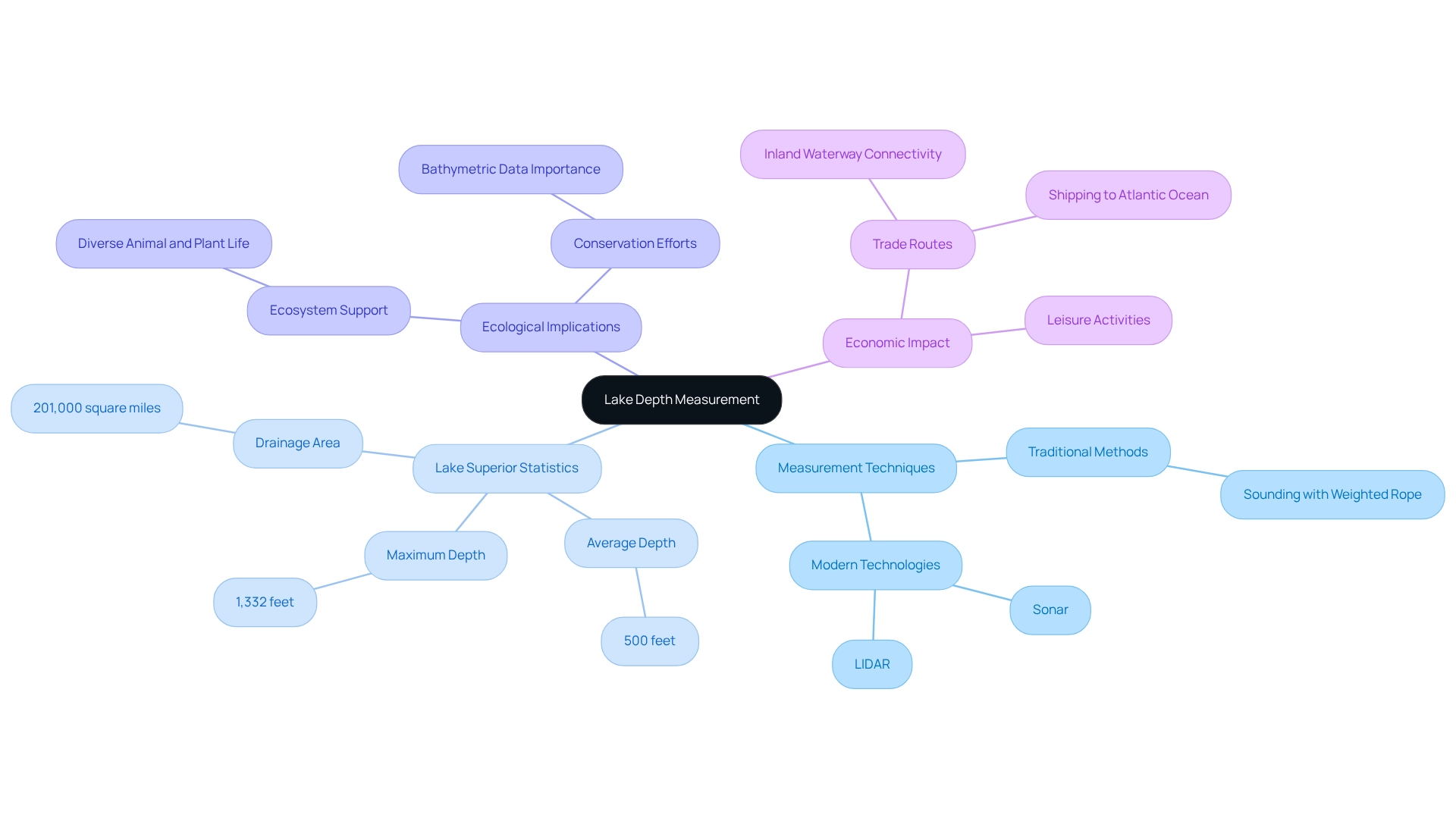
Lake Superior boasts an average depth of approximately 500 feet and reaches a maximum depth of 1,332 feet, establishing it as the deepest of the Great Lakes. This impressive measurement is further substantiated by a thorough exploration of various depth assessment techniques. It encompasses both traditional methods, such as weighted ropes, and cutting-edge technologies like sonar and LIDAR, which significantly enhance the accuracy and efficiency of underwater measurements.
Introduction
Measuring the depths of lakes, especially expansive bodies of water like Lake Superior, is not merely a scientific task; it is a vital endeavor that influences navigation, ecology, and resource management.
With an average depth of approximately 500 feet and a maximum depth reaching 1,332 feet, comprehending these depths is crucial for maintaining the delicate balance of the ecosystem.
As technology progresses, traditional measurement methods are being supplanted by advanced tools such as sonar and LIDAR, which provide unparalleled accuracy and efficiency.
This article explores the diverse techniques and tools essential for effective lake depth measurement, guiding readers through the process while addressing common challenges encountered in the field.
By examining the complexities of measuring Lake Superior's depths, one not only gains a deeper appreciation for this natural marvel but also insights into the broader implications of such measurements on environmental health and economic activities.
Understand the Basics of Lake Depth Measurement
Assessing the dimensions of a lake is essential for comprehending the features of a body of water, particularly in significant lakes such as Lake Superior. This process involves evaluating the extent at various locations using a range of techniques. Traditional methods, such as sounding with a weighted rope, have been largely supplemented by modern technologies like sonar and LIDAR (Light Detection and Ranging), which provide more accurate and efficient measurements.
When discussing how deep Lake Superior is, it boasts an average depth of around 500 feet and a maximum depth of 1,332 feet, making it the deepest of the Great Lakes. Understanding these levels is crucial not only for navigation and leisure activities but also for ecological well-being and resource management. Bathymetric data, which maps the underwater topography, plays a vital role in assessing the lake's ecosystem and informing conservation efforts.
Expert opinions underscore the importance of precise lake measurement. For instance, sonar technology enables detailed mapping of submerged features, while LIDAR can penetrate the surface to deliver accurate readings of elevation. These methods have proven instrumental in various case studies, showcasing their effectiveness in enhancing our understanding of lake environments.
Understanding how deep Lake Superior is extends beyond mere curiosity; it influences ecological research, resource management, and even trade routes. The Great Lakes' extensive drainage region of 201,000 square miles emphasizes the interconnectedness of these bodies and their role in supporting diverse ecosystems. Notably, the trade paths enabled by the Great Lakes' canals and tributaries illustrate how lake measurements can enhance shipping opportunities and economic activities in the area.
As Mehmet Murat Ildan wisely remarked, "There is something more lovely than a lovely thing and that is a lovely thing which has a beautiful reflection on the surface." This reflection serves as a reminder of the complex connection between water levels and ecological balance, encouraging us to value and safeguard these essential resources. Therefore, as you contemplate your next adventure, consider discovering the wonders of Lake Superior and the beauty it possesses beneath the surface.

Gather Necessary Tools and Techniques for Measurement
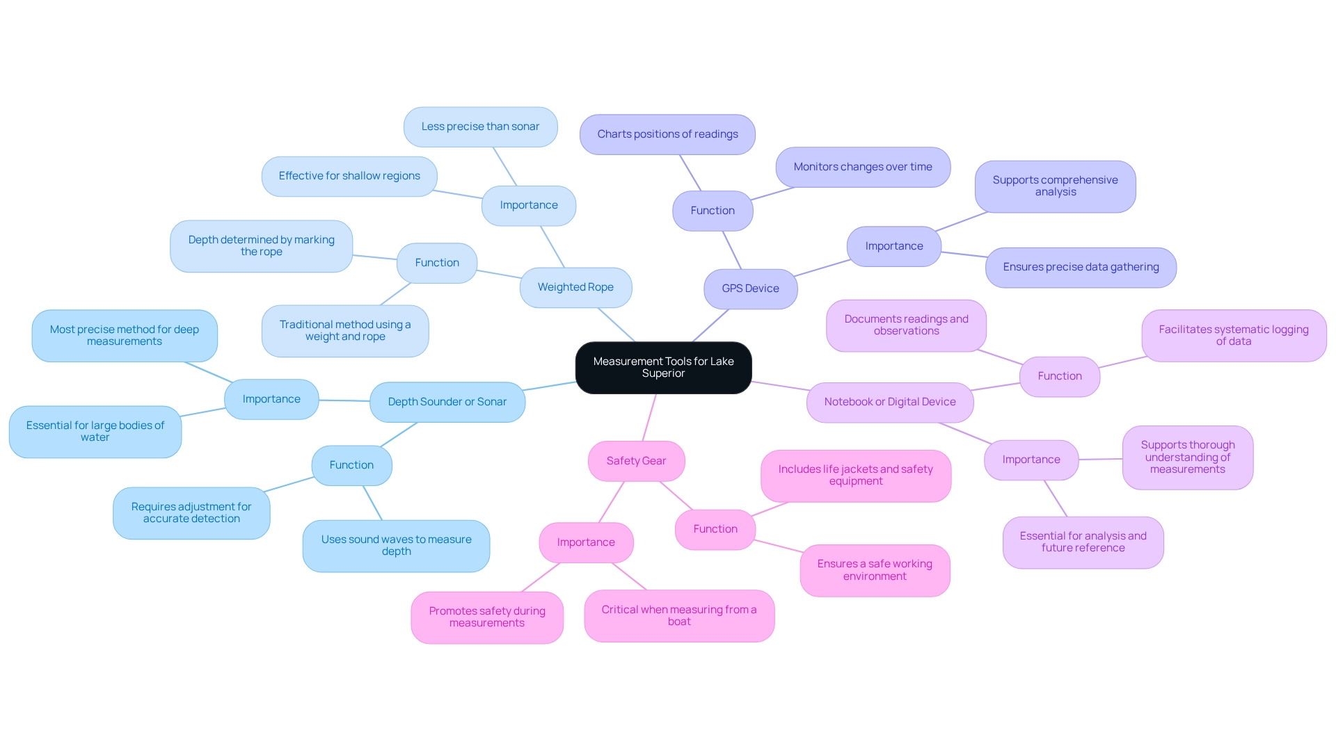
To accurately measure the depth of Lake Superior, employing a selection of specialized tools is essential:
- Depth Sounder or Sonar: Utilizing sound waves, this device measures the distance to the lake bottom, making it the most precise method for deep measurements. Adjusting sonar positioning is crucial for enhanced object detection, as acoustic shadows can obscure nearby objects, impacting detection accuracy.
- Weighted Rope: This traditional method involves attaching a weight to a rope, which is lowered into the liquid until it reaches the bottom. By marking the rope at the water's surface, one can easily determine the depth. While effective, this method may not provide the same level of precision as sonar.
- GPS Device: Crucial for charting the positions of your readings, a GPS device guarantees precise data gathering and assists in monitoring changes over time.
- Notebook or Digital Device: Documenting readings and observations is essential for analysis and future reference. Whether using a traditional notebook or a digital device, ensure that all data is logged systematically.
- Safety Gear: If measuring from a boat, life jackets and other safety equipment are necessary to ensure a safe working environment.
Before starting your measurements, familiarize yourself with the function of each tool, particularly the equipment that may require calibration and a clear understanding of its display. Expert opinions indicate that while weighted rope can be beneficial for shallow regions, acoustic technology is favored for its precision in measuring Lake Superior's depth in larger bodies of water. As Ben noted, "You can always come back later to dive deeper and understand more if you need," emphasizing the importance of thorough understanding in this process. Furthermore, findings from the case study titled 'Advice for Aspiring Sonar Researchers' underscore the importance of establishing clear objectives in sonar research, which aligns effectively with the subject of measuring lake levels. This combination of tools will provide a comprehensive approach to assessing distance, enabling efficient data gathering and analysis.

Follow Step-by-Step Instructions to Measure Depth
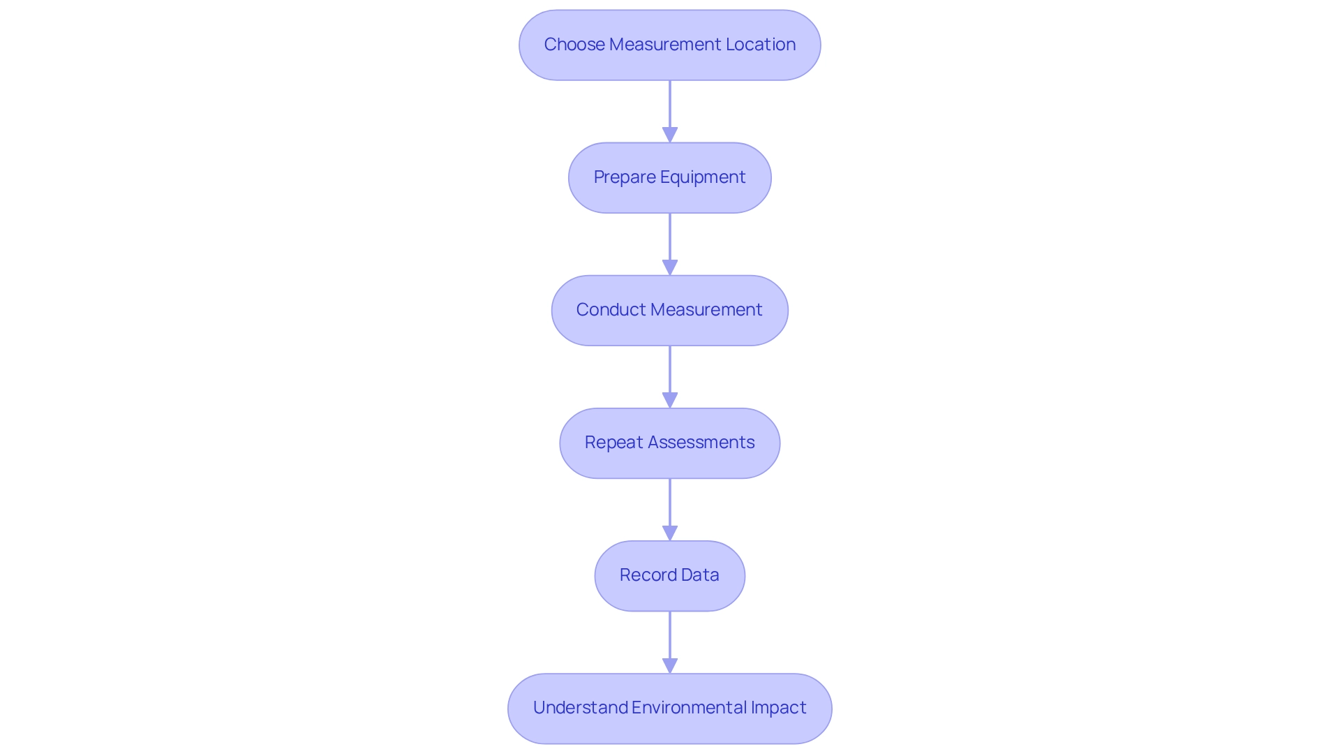
To accurately measure the depth of Lake Superior, follow these detailed steps:
- Choose Your Measurement Location: Identify a specific point on the lake for assessing the depth. Utilize GPS technology to precisely mark this location.
- Prepare Your Equipment: Ensure your sounder is fully charged and calibrated. If opting for a weighted rope, confirm that the weight is securely attached to prevent loss during measurement.
- Conduct the Measurement:
- Using Sonar: Position your boat directly over the chosen point. Turn on the sonar device and let it stabilize before capturing the shown measurement.
- Using Weighted Rope: Lower the weighted rope into the liquid until it reaches the lakebed. Mark the rope at the water's surface, then pull it back to gauge the measurement precisely.
- Repeat Assessments: For improved precision, carry out several assessments at different locations and depths throughout the lake, especially in regions with varying terrain.
- Record Your Data: Document all readings meticulously in a notebook or digital device, including the GPS coordinates for future reference.
To ensure safety and conduct environmental evaluations, it's important to understand Lake Superior how deep it can sustain waves over 10 meters (33 feet). As Captain McSorley, the captain of the Fitzgerald, once stated, "We are holding our own," highlighting the challenges faced in such environments. Furthermore, city personnel are presently examining alterations in lake levels and anticipate offering an update later this year, emphasizing the continued significance of these assessments. By following these steps, you can ensure accurate measurements that contribute to a better understanding of how deep Lake Superior is underwater, which is essential for both environmental evaluations and artistic depictions.

Troubleshoot Common Issues in Depth Measurement
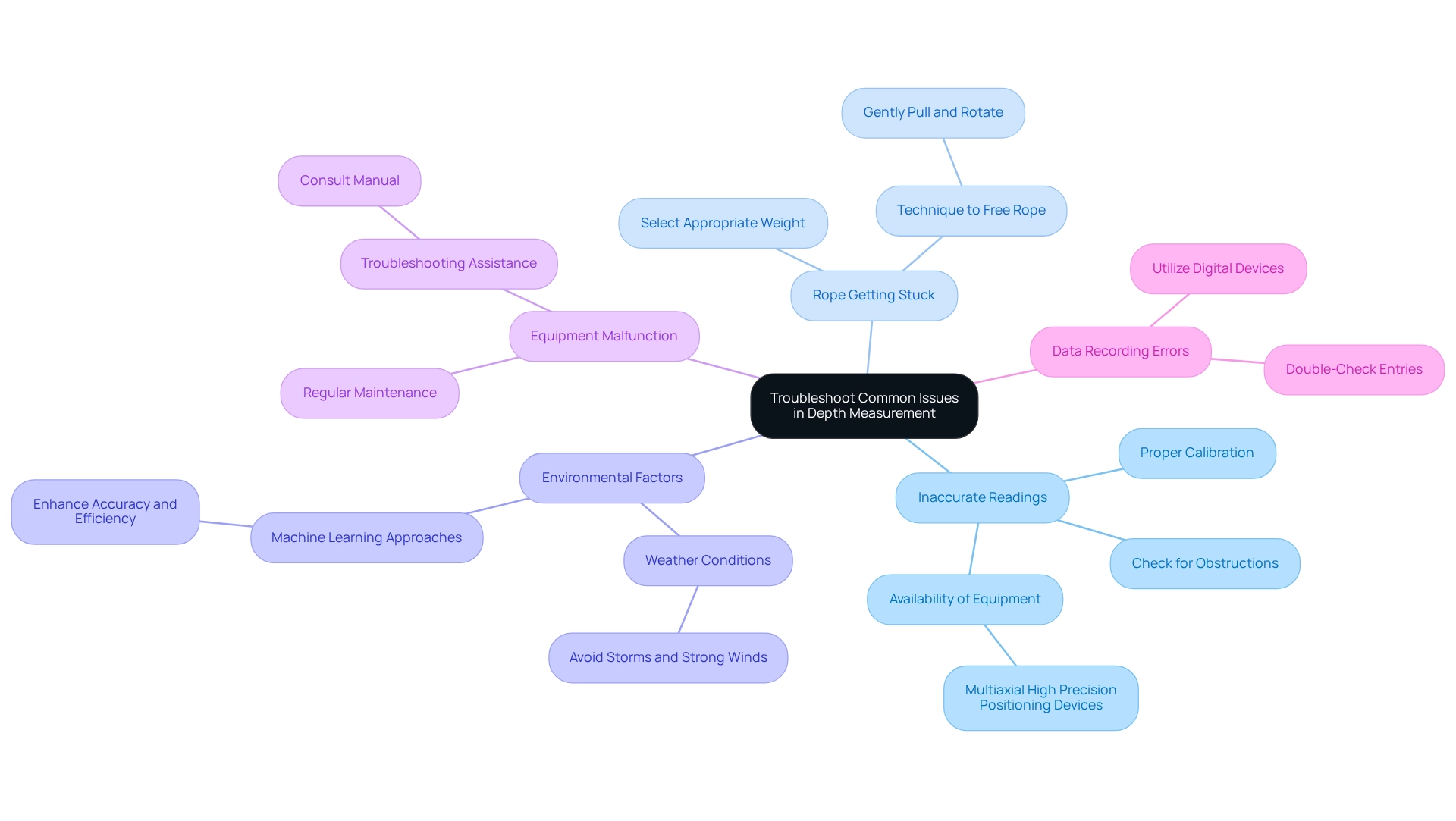
When measuring depth, several common issues may arise that can significantly impact the accuracy and reliability of your results:
- Inaccurate Readings: Proper calibration of sonar devices is crucial. Ensure that the equipment is calibrated correctly and check for any obstructions in the water that could interfere with sound wave propagation. Notably, multiaxial high precision positioning devices for underwater use are often not readily available for online purchase, complicating the acquisition of dependable assessment tools.
- Rope Getting Stuck: For those utilizing a weighted rope, it is essential to select a weight heavy enough to reach the bottom without snagging on underwater structures. Should the rope become stuck, gently pull it upward while rotating to help free it.
- Environmental Factors: Weather conditions greatly affect visibility and safety during assessments. It is advisable to avoid performing assessments during storms or strong winds, as these can lead to inaccurate data collection. Incorporating machine learning approaches can enhance the accuracy and efficiency of measurements by analyzing environmental data.
- Equipment Malfunction: Regular maintenance of your equipment is vital. Check for signs of wear or malfunction, and if the device fails to function properly, consult the manual for troubleshooting assistance. As one specialist remarked, 'Regular inspections and adjustments are crucial to guarantee the dependability of acoustic readings.'
- Data Recording Errors: Accuracy in data recording is paramount. Double-check your entries to avoid miswriting numbers, particularly in challenging conditions. Utilizing a digital device can streamline data entry and reduce the likelihood of errors.
In a case study involving sonar calibration with a tungsten ball, scientists successfully ensured accurate readings of fish populations despite encountering challenges with equipment entanglement. The crew adeptly resolved the entanglement issue by carefully maneuvering the equipment and retrieving the tungsten ball without further complications. This underscores the significance of comprehensive preparation and troubleshooting in field evaluations. By proactively addressing these common issues, you can significantly enhance the reliability of your depth measurement efforts.

Conclusion
Accurate measurement of Lake Superior's depths is not merely a technical endeavor; it is essential for understanding the ecological dynamics and navigating the vast waters of this remarkable lake. By employing advanced technologies such as sonar and LIDAR in conjunction with traditional methods like weighted rope, we enhance both the precision and efficiency of these vital measurements. Each tool and technique plays a critical role in capturing the intricate underwater landscape, informing conservation efforts, resource management, and the economic activities linked to the Great Lakes' trade routes.
Despite the challenges that may arise—ranging from equipment malfunctions to environmental factors—being well-prepared and knowledgeable can significantly mitigate these issues. Adopting a systematic approach to measurement while maintaining meticulous records preserves the integrity of the data collected, contributing to a deeper understanding of Lake Superior's complex ecosystem.
Ultimately, the pursuit of measuring lake depths transcends mere scientific inquiry; it embodies a commitment to preserving and appreciating the natural beauty and ecological health of one of North America's greatest freshwater resources. Embracing these practices fosters a greater respect for our environment and supports the sustainable management of vital aquatic ecosystems for future generations. This commitment to excellence not only enhances our understanding but also ensures that we protect and cherish this invaluable resource.
Frequently Asked Questions
Why is assessing the dimensions of a lake important?
Assessing the dimensions of a lake is essential for understanding its features, which impacts navigation, leisure activities, ecological well-being, and resource management.
What are the traditional and modern techniques used to measure lake dimensions?
Traditional methods include sounding with a weighted rope, while modern technologies such as sonar and LIDAR (Light Detection and Ranging) provide more accurate and efficient measurements.
What is the average and maximum depth of Lake Superior?
Lake Superior has an average depth of around 500 feet and a maximum depth of 1,332 feet, making it the deepest of the Great Lakes.
How does bathymetric data contribute to lake assessment?
Bathymetric data maps the underwater topography, which is crucial for assessing the lake's ecosystem and informing conservation efforts.
What role does sonar technology play in lake measurement?
Sonar technology enables detailed mapping of submerged features, enhancing our understanding of lake environments.
How does LIDAR technology assist in measuring lakes?
LIDAR can penetrate the water surface to provide accurate readings of elevation, contributing to precise lake measurements.
Why is the depth of Lake Superior significant beyond curiosity?
The depth influences ecological research, resource management, and trade routes, highlighting the interconnectedness of the Great Lakes and their ecosystems.
What is the area of the Great Lakes' drainage region, and why is it important?
The Great Lakes' drainage region covers 201,000 square miles, emphasizing the interconnectedness of these bodies of water and their role in supporting diverse ecosystems.
How do lake measurements impact shipping and economic activities?
Lake measurements can enhance shipping opportunities and economic activities by improving navigation through trade paths enabled by the Great Lakes' canals and tributaries.


