Lake Superior is 1,332 feet deep at its deepest point.
That's the number. You probably came here for it. But numbers are strange things. They answer the question without telling you anything real.
1,332 feet. That's taller than the Empire State Building. If you dropped a school bus into the deepest point of Lake Superior, it would take roughly 40 seconds to reach the bottom, sinking through water so cold and dark that nothing looks like what you'd expect. The bottom isn't flat. It's a landscape. Ridges, valleys, basins carved over billions of years. An entire hidden world beneath the surface that almost nobody will ever see.
That's what makes depth interesting. Not the number. The fact that there's a whole other version of a place, existing right beneath the one you know.
What's Actually Down There
Lake Superior sits in a basin formed by a failed continental rift that began roughly 1.1 billion years ago. The earth tried to split apart, failed, and left behind a massive depression that eventually filled with glacial meltwater. The lake as we know it took shape about 10,000 years ago when the last ice sheets retreated.
The deepest point sits in the eastern portion of the lake, roughly 40 miles north of Munising, Michigan. But the floor isn't a single bowl. It's a series of basins separated by underwater ridges. The western basin is shallower, around 600 to 800 feet. The central and eastern basins plunge deeper, with the eastern basin holding that maximum depth of 1,332 feet (406 metres).
If you could drain the water, you'd see something that looks more like a mountain range than a lake bed. Steep drop-offs. Flat plains of sediment. Rocky outcrops. Underwater cliffs.
The average depth is 483 feet. That means most of Lake Superior is deep enough that sunlight can't reach the bottom. Below about 200 feet, it's permanent darkness.
The Cold That Preserves Everything
At its deepest points, Lake Superior hovers around 39°F (4°C) year-round. This is the temperature at which fresh water is densest, so the coldest water sinks and stays. In summer, the surface can warm to 60°F or higher, but below the thermocline (the boundary where warm water meets cold), temperatures barely change regardless of season.
This cold does something remarkable. It preserves.
Lake Superior holds an estimated 350 shipwrecks, and many of them are in startlingly good condition. The cold, fresh water inhibits the bacteria and organisms that break down wood in warmer waters. The Edmund Fitzgerald, which sank in 1975 in 530 feet of water, was found largely intact on the lake floor. Older wrecks from the 1800s have been discovered with their masts still standing, their hulls barely touched by time.
The lake doesn't give up its dead easily. That's not just poetry. The cold water inhibits the bacterial gases that normally cause bodies to float to the surface. Gordon Lightfoot put it plainly: "The lake, it is said, never gives up her dead." He wasn't wrong.
Why Depth Looks Different When You Map It

Here's where this gets interesting in a way most depth articles can't show you.
Bathymetry is the study of underwater topography. It's how scientists measure and map the shape of a lake floor, ocean floor, or any body of water. The data comes from sonar surveys, satellite readings, and decades of measurement. When you plot it in three dimensions, you stop seeing a lake and start seeing a landscape.
That's exactly what Pangea Maps does. Each map takes real bathymetric data and translates it into nine layers of laser-cut European birch plywood. The shallowest areas sit highest. The deepest points drop lowest. You can see the ridges, the basins, the shelves, the drop-offs. The hidden world, made visible.
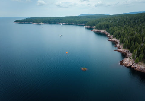
Most people experience Lake Superior from the surface. You see the water, the horizon, the waves. Maybe you've kayaked the Pictured Rocks or fished off the shore at Duluth or driven the Trans-Canada Highway along the northern coast. But the lake beneath is just as dramatic as the one above. More, maybe. You just can't see it.
Unless you put it on your wall.
People who order a Pangea map of Lake Superior aren't buying a decoration. They're holding onto a connection. The lake where their family has a cottage. The water they've sailed since childhood. The place that means something no photograph can capture because the meaning is in what's beneath the surface.
Hannah described hers as a "stylish opportunity to recall our favourite holiday destination every time I look at it." And that's what it becomes. Not just art. A daily reminder of a place you love, rendered in a way you've never seen it before.
Every visitor who sees it on the wall asks the same thing: "What is that?" And then the story comes out. Where it is. Why it matters. What happened there. The map becomes a conversation that wouldn't have happened otherwise.

Lake Superior by the Numbers
For the fact-seekers. The full picture.
- Maximum depth: 1,332 feet (406 metres)
- Average depth: 483 feet (147 metres)
- Surface area: 31,700 square miles, the largest freshwater lake by surface area on Earth
- Volume: 2,900 cubic miles of water. Enough to flood all of North and South America to a depth of one foot
- Length: 350 miles
- Width: 160 miles at its widest
- Shoreline: 2,726 miles
- Water temperature at depth: ~39°F (4°C) year-round
- Estimated shipwrecks: 350+
- Age of the basin: ~1.1 billion years (rift formation); ~10,000 years (current lake)
- Retention time: 191 years. A drop of water entering Lake Superior today won't leave for almost two centuries
A Place Worth Knowing Deeply
Lake Superior is one of those places that gets more interesting the more you learn about it. The surface is beautiful. Everyone knows that. But the depth, the cold, the geology, the wrecks, the sheer scale of what's hidden below: that's where the real character lives.
1,332 feet. Now you know the number. But the next time you're standing on the shore of Lake Superior, looking out at water that stretches to the horizon, remember: you're only seeing half of it. The other half is an ancient, cold, dark, stunningly sculpted world that most people will never see.
Some people frame a photo. Others put the whole hidden landscape on their wall.

