Overview
The article examines the distinctive features and profound significance of maps of Lake Michigan, underscoring their vital role in navigation, education, and cultural representation. These maps are not merely tools; they are meticulously crafted representations that weave together geographical details, historical context, and ecological insights. They reflect the lake's critical importance to surrounding communities and the urgent need for ongoing environmental stewardship. Such maps are designed to capture your unique story, emphasizing the craftsmanship that goes into each one.
Introduction
The intricate landscape of Lake Michigan is not merely a natural wonder; it serves as a canvas of history, ecology, and human interaction. Maps of this vast body of water are vital tools that reveal its geographical features and cultural significance, while offering insights into its ecological dynamics and historical context. Yet, what do these maps truly represent beyond mere navigation? They blend artistry with functionality, presenting a challenge in understanding how these representations can deepen appreciation for Lake Michigan's legacy and the ongoing environmental issues it faces.
Define a Map of Lake Michigan
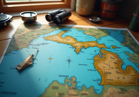
A map of Lake Michigan serves as a detailed visual representation that highlights the geographical features, topography, and notable landmarks of the region. These charts include a map of Lake Michigan that ranges from simple outlines defining the lake's limits to intricate topographic representations revealing submerged features and surrounding terrains. Functionally, the Great Lakes charts address varied needs:
- They aid boaters in navigation
- Act as educational tools for students
- Provide artistic representations that enhance home decor
Beyond their practical applications, these representations encapsulate the cultural and historical significance of the region, making them invaluable for both functional use and personal reflection.
The creative interpretations of the Great Waters charts have gained popularity, with many individuals seeking unique pieces that resonate emotionally. These handcrafted maps transform spaces into showcases of cherished memories and connections to the body of water, designed to capture your unique story. Explore the craftsmanship and customization options available, and consider how these exceptional pieces can enhance your environment. Inquire today to discover how you can bring a piece of the Great Lakes into your home.
Explore the Historical Context and Significance
The large body of water stands as a cornerstone for the development of surrounding communities and economies, serving as a vital transportation route since the days of Native American tribes and later European settlers. The earliest charts, including the map of Lake Michigan, dating back to the 17th century, underscored its importance for navigation and trade, laying the groundwork for future exploration and commerce.
As cartographic techniques evolved, the map of Lake Michigan began to incorporate intricate details regarding the body of water's ecology, geology, and the human impact on its environment. Notably, the introduction of coho salmon transformed the waters from a near ichthyological desert into an angler’s paradise, highlighting the area’s ecological significance.
Today, this large body of water is celebrated not only for its breathtaking natural beauty but also for its rich historical legacy as a hub of commerce and recreation. The map of Lake Michigan serves as an enduring symbol of its history and current state, reflecting its ongoing influence on nearby communities and economies.
As David Lodge, a University of Wisconsin ecologist, remarked, 'If you want to know what’s coming next, look at the species that are already in the Great Lakes,' which emphasizes the necessity of understanding the ecological dynamics at play.
Furthermore, the pollution in the Cuyahoga River serves as a stark reminder of the environmental challenges that continue to affect the Great Lakes region, calling for a comprehensive approach to ecological stewardship.

Identify Key Features of Lake Michigan Maps
The intricate bathymetric features of the map of Lake Michigan reveal the underwater topography and depth variations of the lake. Notably, the Chippewa Basin reaches depths exceeding 275 meters, while the South Chippewa Basin boasts a maximum depth of over 165 meters. These charts prominently display significant landmarks, including a map of Lake Michigan featuring iconic lighthouses, expansive parks, and well-known recreational zones, alongside essential ecological features such as wetlands and wildlife habitats.
Furthermore, they illustrate human-made structures like marinas and shipping channels, which play a crucial role in navigation and commerce. The historical significance of shipwrecks, such as the steamship Milwaukee found over 350 feet below the surface, adds a rich cultural context to the underwater landscape. Recent discoveries, including the wrecks of the Margaret A. Muir and the Adella Shores, underscore the importance of these charts in revealing historical artifacts.
By incorporating these diverse elements, the map of Lake Michigan not only facilitates practical navigation but also enhances the understanding of the lake's ecological and cultural landscape, making it essential for educational purposes and artistic expression. Moreover, Pangea Maps offers customizable 3D representations that honor personal narratives and experiences, crafted from environmentally sourced materials. These handcrafted artworks serve as unique representations of cherished locations, making them ideal for personalized gifts and corporate gifting solutions.

Examine Different Types of Lake Michigan Maps
Lake Michigan offers an exceptional array of resources, including a detailed map of Lake Michigan, each tailored to meet specific needs. Nautical charts are indispensable for mariners, providing crucial information on water depths, navigational hazards, and buoy placements—elements vital for safe navigation. Topographic representations, such as a map of Lake Michigan, reveal the land surrounding the lake, illustrating elevation changes and natural features essential for grasping the area's geography. Bathymetric charts delve into the underwater landscape, offering depth contours and uncovering submerged formations critical for navigation and ecological research.
Moreover, creative geographic representations, such as those crafted by Pangea Maps, transform geographical data into bespoke artworks that celebrate significant locations and cherished memories for individuals and businesses. Each map is meticulously hand-sketched over bathymetric ocean charts, with custom designs taking approximately an hour to create, all hand glued and framed locally. These artistic interpretations not only enhance traditional maps but also serve as meaningful gifts for special occasions, making them perfect for corporate gifting managers in search of unique presents.
With less than 15 percent of the Great Lakes mapped at high resolution, the significance of these diverse map types, particularly the map of Lake Michigan, cannot be overstated; they play a pivotal role in navigation, environmental management, and personal expression.

Conclusion
The map of Lake Michigan stands as an indispensable tool that encapsulates the lake's unique geographical features, historical significance, and ecological dynamics. It not only facilitates navigation and educational pursuits but also celebrates the cultural essence of the region, making it a vital resource for both practical and artistic applications.
Key insights explored throughout this article highlight the historical context that underscores the lake's importance as a transportation route and economic hub. The intricate details of its underwater topography and the diverse types of maps available for various needs further enrich our understanding. From nautical charts essential for safe navigation to artistic representations that evoke personal connections, each map tells a unique story about Lake Michigan and its enduring influence.
Understanding the significance of Lake Michigan maps transcends mere navigation; it invites reflection on the environmental challenges and historical legacies that shape the region today. Embracing these maps not only enhances personal spaces but also fosters a deeper appreciation for the natural world and its intricate ecosystems. Engaging with the beauty and history of Lake Michigan through its maps encourages stewardship and connection, urging individuals to explore, cherish, and protect this invaluable resource.
Frequently Asked Questions
What is a map of Lake Michigan?
A map of Lake Michigan is a visual representation that highlights the geographical features, topography, and notable landmarks of the region, ranging from simple outlines to intricate topographic details.
What are the different uses of Lake Michigan maps?
Lake Michigan maps serve various purposes including aiding boaters in navigation, acting as educational tools for students, and providing artistic representations that enhance home decor.
Why are maps of Lake Michigan culturally and historically significant?
These maps encapsulate the cultural and historical significance of the region, making them valuable for both practical use and personal reflection.
What is the trend regarding handcrafted maps of the Great Lakes?
Handcrafted maps of the Great Lakes have gained popularity, with individuals seeking unique pieces that resonate emotionally and transform spaces into showcases of cherished memories.
How can I enhance my environment with a map of Lake Michigan?
You can explore craftsmanship and customization options for maps of Lake Michigan to bring a piece of the Great Lakes into your home, reflecting your unique story and connections to the water.